CAPTAIN SEGULL'S NAUTICAL CHART
CAPTAIN SEGULL'S NAUTICAL CHART - OFFSHORE CANYON DETAIL MA, CT, RI & NY is backordered and will ship as soon as it is back in stock.
Couldn't load pickup availability
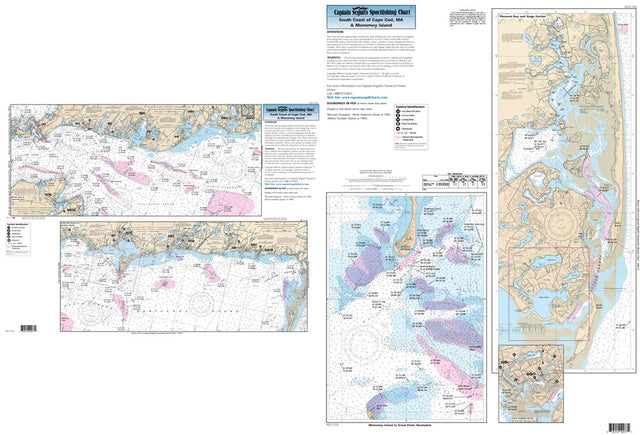
Captain Segull Chart - South Coast of Cape Cod- MA & Monomoy
An inshore chart 1-2 miles off the coast, detailing the bays. Chart is 19 x 26 inches, double sided, and laminated.
South Coast of Cape Cod, plus Stage Harbor, Pleasant Bay, and Monomoy. All charts include GPS coordinates, wrecks, reefs, shoals, fishing areas, amenities and restrictions. Also refer to our nearshore, inshore, bathymetric, and offshore charts in this area.
Captain Segull Chart - Offshore Canyon Detail MA, CT, RI & NY
Offshore - 90 to 100 miles off coast, Double sided, laminated, 19 x 26 inches. MA, RI, CT, & NY.
Side A: from Nantucket Shoals to mid Long Island, NY south to cover all canyons beginning with the Veatch Canyon to Hudson Canyon. Side B: a blow up of the very important fishing spots off Block Island Sound, including the Dump, The Finger's Cox's Ledge and many more. The chart is blown up for people that are going out of Montauk, RI, CT and MA. Please refer to our nearshore, inshore, offshore, bathymetric and small boat/kayak charts in this area.
Captain Segull Chart - Nantucket Shoals & Georges Bank
Offshore chart, 90 to 100 miles off coast, Double sided, laminated, 19 x 26 inches. Massachusetts coastline.
Offshore canyon chart, side A: from west of Nantucket east to the Corsair Canyon and to the Canadian line, begins with the Veatch Canyon, includes the Winter Fishing Grounds. Side B: nearshore chart detail of Nantucket and Nantucket Shoals, west to eastern half to Martha's Vineyard to 10 miles east of Nantucket. All charts include GPS coordinates, wrecks, reefs, shoals, fishing areas, amenities and restrictions. Please refer to our inshore, nearshore, offshore and bathymetric charts in this area.
Captain Segull Chart - Gulf of Maine & Massachusetts Bay
Offshore chart off 90 to 100 miles off coast, double sided, laminated, 19 x 26 inches, Maine, New Hampshire, and Massachusetts,
Offshore chart, Side A, the Gulf of Maine from Penobscot Bay to Boston, Massachusetts Bay, includes an inset of Portland Harbor, ME. Side B, Massachusetts Bay, Boston south to Provincetown and Duxbury, MA includes a bathymetric inset of Stellwagen Bank. Please refer to our inshore, nearshore, offshore, bathymetric and small boat/kayak charts in this area.
Captain Segull Chart - Isle of Shoals to Duxbury
Bathymetric - color contoured by depth - double sided, laminated, 19 x 26 inches, Massachusetts Bay area
Nearshore Bathymetric Chart side A: Isle of Shoals, New Hampshire to Duxbury Beach, MA, east to Wildcat Knoll with Stellwagen Bank. Side B: Wildcat Knoll to Wright Swell, north to Cashes Ledge to Franklin Swell. All charts include GPS coordinates, wrecks, reefs, shoals, fishing areas, amenities and restrictions. You should use this chart in conjunction with our NOAA based charts.
Captain Segull Chart - Harbors of Cape Cod - MA
Nearshore 20-30: and an Inshore 1 - 2 Miles off the coast, double sided, laminated, 19 x 26 inches, from the Cape Cod Canal to Provincetown, MA
An inshore chart 1-2 miles off the coast detailing the bays. Side A: Detail of Sesuit, Barnstable, Wellfleet and Provincetown Harbors. Side B: Nearshore: Entire Cape Cod Bay. Cape Cod Canal is on the Buzzards Bay chart. All charts include GPS coordinates, wrecks, reefs, shoals, fishing areas, amenities and restrictions. Please refer to our nearshore, offshore and bathymetric charts.
Captain Segull Chart - Shark Identification
24 different sharks identified double sided 19 x 26 inches
Twenty-four different sharks depicted. Scientists from Woods Hole, MA consulted giving the most scientifically correct pictures of local sharks that are caught in the Atlantic Ocean. Also describes anatomy of a shark and shows pictures of the teeth structure.
Captain Segull Chart - Fishes of the North Atlantic
60 different fish identified double sided, laminated, 19 x 26 inches
Fish Identification chart. Shows you what fish you just caught. Explains the structure of the fish and special qualifications of a fish. Also has an area that teaches you how to clean and gut a fish.
Captain Segull Chart - Portsmouth, New Hampshire to Cape Ann, MA
Bathymetric - color coded by depth - double sided, laminated, 19 x 26 inches, North Shore, Massachusetts
A detailed chart color coded by depth on one side and a regular NOAA chart on the other side. GPS coordinates on all fishing spots. From Cape Ann, MA offshore to Jeffrey's Ledge.
Captain Segull Chart - Nantucket Shoals & Georges Bank, MA
Captain Seagull's Nantucket Shoals and Georges Bank MA Nautical Chart is a an offshore chart, 90 to 100 miles off coast, Double sided, laminated, 19 x 26 inches. Massachusetts coastline.
Offshore canyon chart, side A: from west of Nantucket east to the Corsair Canyon and to the Canadian line, begins with the Veatch Canyon, includes the Winter Fishing Grounds. Side B: nearshore chart detail of Nantucket and Nantucket Shoals, west to eastern half to Martha's Vineyard to 10 miles east of Nantucket. All charts include GPS coordinates, wrecks, reefs, shoals, fishing areas, amenities and restrictions.
Captain Segull Chart - Offshore MA, CI, RI & NY
Offshore - 90 to 100 miles off coast, Double sided, laminated, 19 x 26 inches. MA, RI, CT, & NY.
Side A: from Nantucket Shoals to mid Long Island, NY south to cover all canyons beginning with the Veatch Canyon to Hudson Canyon. Side B: a blow up of the very important fishing spots off Block Island Sound, including the Dump, The Finger's Cox's Ledge and many more. You don't have to purchase both the OF10 and the OFGPS18, they cover the same area. The OF10 is blown up for people that are going out of Montauk, RI, CT and MA. Please refer to our nearshore, inshore, offshore, bathymetric and small boat/kayak charts in this area.
Captain Segull Chart - Nearshore Bathymetric Conn, RI & MA
Bathymetric - color contoured by depth - Double sided, laminated, 19 x 26 inches, Nearshore, RI, CT& NY area
Nearshore and Inshore Bathymetric chart 10 - 20 miles off coast, Side A: Montauk, NY east to western tip of Martha's Vineyard. CT, RI & MA great detail of Mud Hole, Great Triangle, the Claw and many others, Side B: from New Haven CT, west to Fishers Island with in the Long Island Sound. Gardiner's Bay, Six mile Reef and other sites. You should use this chart in conjunction with our other NOAA based charts.

CAPTAIN SEGULL'S NAUTICAL CHART